Upstream Dams on the Mara River

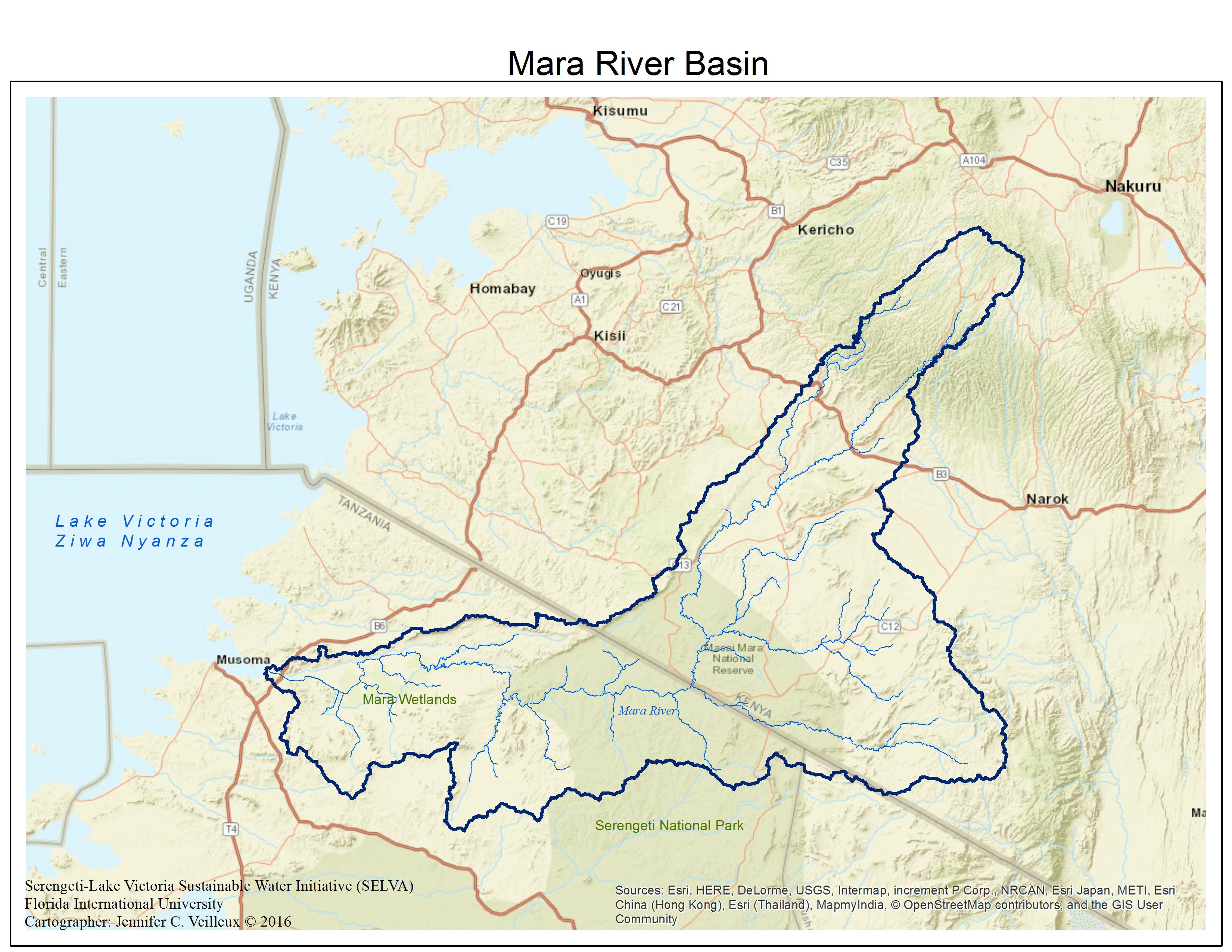
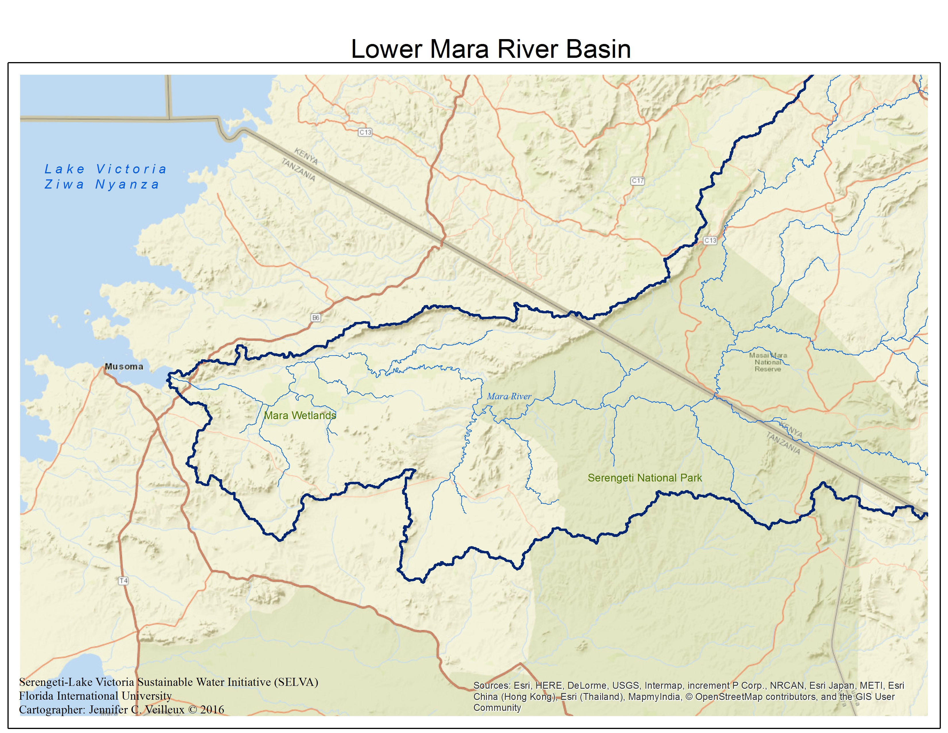
A recent article in the news tells about the Itare Dam, a foreign direct investment dam planned in the Mau Forest that will impact the headwaters of the Mara River. The article claims that the government did not conduct a prior consultation with the residents of the area and that water is in danger of diversion from 12 rivers that originate in the area. The article also points out that this diversion threatens the ecosystems and economic basis of tourism currently afforded in the Maasai Mara. As Serengeti is just across the political border, this sentiment also extends to the fragile ecosystems contained in the Serengeti as well.

Loss of natural water flow in wild rivers has changed ecosystems and socio-cultural community networks all over the world. Itari is one of several dams planned for the waters in the west of Kenya. The World Bank under the guise of the Nile Basin Initiative, has been conducting feasibility studies on waterways all over the Nile Basin. They have identified at least two viable sites for dam construction in the Mara River Basin in Kenya. These projects are designed to generate hydropower and help with year round irrigation efforts for local farms. But as corporate farms take over more and more of the landscape in East Africa, one starts to wonder who will benefit from this water development in the short and long term.

As scientists with SELVA, we realize that we are in a race against time to cultivate a comprehensive collection of baseline data about the water resources in the Lower Mara River Basin. We are doing this through our field collections both in person and through remote collection. Our work is in collaboration with government bodies in Tanzania, including the Ministry of Water and this partnership allows for this collection to continue after the conclusion of the SELVA Initiative.

Posted in agriculture, basin management, communities, economics, environment, Mara River basin, natural resources, SELVA, Serengeti, sustainable water, Tanzania, water resources, water security

Upstream Impacts on Lower Mara River

ogiek

The Ogiek People. http://www.survivalinternational.org/tribes/ogiek

In any shared basin there are upstream and downstream impacts that can affect users of the shared water resources. These impacts, sometimes called “drivers”, range from policy and economic activity, to pollution and diversion actions. The Mau Forest Complex, the largest montane forest stand in East Africa, is part of the headwaters of the Mara River. In theory the Mau Forest provides a natural way of filtering water and the soils, held in place by the trees, allow for permeation, a gradual process of precipitation contribution to surface waters. The soils also, in the case of a healthy forest, contribute less to erosion material as soil is held in place by vegetation. However, there are news reports and research information that encroachment and illegal timber harvesting have reduced the Mau Forest over the last decades.  The indigenous community living in the forest, the Ogiek, report that corruption in the Kenyan government has lead to reduction in the forest. Several years ago Kenyan government’s corruption led to massive tea plantation establishment in the forest, drawing off ground water resources and contaminating the Mara and other water resources that originate in the Mau Forest.

Coordination across the border between Tanzania and Kenya is vital for the sustainable use of water resources in the Mara River Basin, both for humans and the ecosystem. Deforestation contributes to water loss and localized climate change. To date, an MOU has been signed for the Mara, but no official agreements have been finalized between the countries on their shared waterways. Situations like the encroachment of the Mau Forest, at the headwaters of the Mara, can have lasting downstream negative impacts. Erosion will increase with deforestation, and the healthy filtration that the forest provides will no longer function. Keeping forests in place in areas of river headwaters and along river banks is important for the overall health of the river system. The Mara River is no exception. Torrential rains that come in the rainy season can easily strip unprotected top soil away – leaving farmers with land that has less growing potential and value, and downstream communities with more pollutants, more sedimentation, and less clean, safe, water to use.

Posted in agriculture, basin management, communities, culture, economics, ecosystems, environment, Mara River basin, natural resources, non-river resources, sustainable water, water resources, water security, wildlife

Subsistence Economies on the Mara River

Photo credit: Elizabeth Anderson © 2016

Fish Market, Musoma, Mara Region, Tanzania Photo credit: Elizabeth Anderson © 2016

The SELVA team found on our fieldtrip in March 2016, that subsistence communities are the majority of stakeholders in the lower Mara River Basin in Tanzania. Subsistence is an economic term that refers to when a person or people work to maintain themselves or support the community at the minimum level for survival. As mentioned in previous posts, the local people, mostly Kurya, keep livestock, farm, fish, and mine. While some describe subsistence as what people do to stay alive and exist, I find that this term can also be applied to those people and communities that do not exploit natural resources for gain, do not take more than necessary for themselves and their community, and as a result, live in a sustainable fashion. Subsistence markets exist, selling farming goods or fish and sometimes the exchanges are bartered rather than handled in cash. However, whether barter or cash, subsistence markets are usually closed economically: the money never enters the regional or national economies.

While some subsistence communities are also sustainable communities, this is not necessarily the case in the Mara River Basin. Population increases have put pressure on environmental resources at the subsistence level, but also external pressures from commercial fishing, farming, charcoal production, and mining added together are resulting in environmental degradation to the forests, soils, habitat, biodiversity, and of course, the water and make even a subsistence life impossible for some stakeholders.

Many subsistence cultures around the world are adapting and modifying traditional ways to cope with global changes in climate, weather, development-driven changes, and depleted or eliminated resources access due to overexploitation from commercial industries. This has been going on for the better part of a century. In the lower Mara River Basin conservation efforts are competing with local subsistence leaning on available resources. Locals reported to SELVA that they had some food and water insecurity for part of the year. In the mining area, local mining efforts are often deemed illegal, while a foreign mining company has mineral rights and access through an agreement with Tanzania’s national government. Mining waste has contaminated otherwise viable soils and water around the North Mara Mines, reducing further farmland and safe drinking water options. There is an economic compensation package in place with the North Mara Mines to the Tarime District, though it was not apparent where the money for infrastructure was going in the mining areas near to the Mara River. Though it was not immediately evident or obvious what local stakeholders will do to adapt to resources changes, some people reported changing from fishing livelihoods to farming full time.

Posted in agriculture, communities, economics, environment, fish, Kurya, Mara River basin, mining, natural resources, non-river resources, SELVA, sustainable water, Tanzania, water resources

The Kurya People

Kurya Elder from Nyasurura

Kurya Elder from Nyasurura © 2016 Jennifer Veilleux

The largest ethnic group living in the lower Mara River Basin, Tanzania, are the Kurya People; a Bantu speaking people with possible Nilotic origins. The Kurya are an ethnic minority of about approximately 700,000-1,000,000 people living in a collection of subtribal groups or clans across the border area of Kenya and Tanzania in the basin region. The SELVA team spoke with Kurya people living across the lower basin and encountered communities living more traditionally in mud huts near the river, and communities that live in modern structures. One of our team members is ethnically Kurya and told us that while he understood most of the local language generally, each place we visited had words unfamiliar to him.

Children cross bridge over the Mara River © Jennifer Veilleux

Kurya children cross bridge over the Mara River © Jennifer Veilleux

Some Kurya maintain traditional value systems and law unique within the modern Tanzanian system. This includes how the community uses natural resources and maintains culture. Kurya are known as cattle herders and farmers – and previous posts have discussed the practices in the basin that lead to erosion and water contamination. In the past, cattle herding led to intertribal conflict with the Maasai, their neighboring tribal communities. While some people practice traditional subsistence fishing techniques, most commercial fishing is done by non-Kurya who come to the region and form fishing camps.

Kurya Woman near Kirume Bridge © Jennifer Veilleux

Kurya Woman near Kirume Bridge © Jennifer Veilleux

Kurya practice polygamy – one man can marry several wives depending on the number of cattle he has for a dowry. When we were in the field we were told the number of huts in a boma, a collection of round huts arranged in a circle, tell how many wives one family contains. Kurya also practice circumcision rites both for male and female tribal peoples, as a complicated rite of passage to adulthood decided by the community. Young women are typically married off to older Kurya men as marriage is traditionally arranged with a dowry of cattle provided by the potential husband in exchange for a young bride. A recent news article discussed one traditional custom that allows women to opt out of marriage with a man to marry one another and pool their resources together.

Kurya Farmer and her children © Jennifer Veilleux

Kurya Farmer and her children © Jennifer Veilleux

Kurya women play and integral role in water gathering and management at the household level, as discussed in a previous post. SELVA met one woman who not only leads her community, but also handles the upper management of the village water situation: this is the exception. While women are typically responsible for farming in the traditional communities, they cannot own land. Women are tasked with all things domestic, including minding the children, washing, cooking, and fetching water. The arrangement of multiple wives to one household reduces the overall burden of these responsibilities on one women, and the SELVA team spoke with women who described how some duties are divided between wives. However, women we spoke with were careful to point out that while they cooperate, each wife have separate quarters and the rank in wife order (ex. wife number one handles finances, wife number two is married for love, wife three to farm) figures into their respective duties.

Kurya Community Leader © Jennifer Veilleux

Kurya Community Leader © Jennifer Veilleux

Posted in agriculture, basin management, communities, culture, ecosystems, environment, Kurya, Lake Victoria, Mara River basin, natural resources, SELVA, sustainable water, Tanzania, water resources, water security, women

Happy World Mara Day!

Written by: Ana Lemos
Photo credit: Ana Lemos

Photo credit: Ana Lemos

Thursday, September 15 is world Mara Day– a day that celebrates the Mara River and the world famous Mara landscape. As a nod to the transboundary nature of the Mara River, the 10th Sectoral Council of Ministers for the Lake Victoria Basin in 2012 chose to celebrate the river on September 15 of every year as it coincides with the great migration of wildlife from Serengeti National Park in Tanzania to Maasai-Mara National Reserve in Kenya. Mara Day celebrations are rotated on an annual basis between Kenya and Tanzania. In 2015, celebrations were hosted in Tanzania in the town of Butiyama- birth place of Tanzania’s first president Julius Nyerere.
 
Hundreds of thousands of people from Kenya and Tanzania will come together today to celebrate the 5th annual World Mara Day in Bomet, Kenya. This year’s theme is “Mara Conservation, My Responsibility” and seeks to create awareness among stakeholders on the importance of the Mara River Basin and its resources, promote river bank protection, and improve water management practices. During this day, people will reflect on the importance of the Mara River and how their actions can contribute to the conservation of the landscape. The SELVA team found that several communities throughout the Tanzanian side of the Mara River Basin are implementing conservation strategies such as limiting fishing during certain times of the year, reforestation of riparian zones, and the organization of stakeholders for resource management.
 
The future of the Mara River Basin depends on the health of the river. Current threats to the Mara River Basin are pollution from agriculture and mining, deforestation, and global climate change. These threats are a cause for concern because not only is the river a main water source for people for drinking and domestic needs, it is also home to many types of wildlife. These animals and plants are economically important as they are used for tourism and materials for building houses, baskets, and fishing instruments can be found in or near the river. Mara Day is an opportunity to reflect on the importance of the river to the local population, wildlife, and ensuring its existence for generations to come.
Posted in agriculture, basin management, communities, culture, ecosystems, environment, fish, gold, Mara River basin, mining, natural resources, SELVA, Serengeti, sustainable water, Tanzania, water resources, water security, wildlife

Mara River Basin is a Transboundary Basin

politicalentiremarahydro_labels

SELVA generated map

The Mara River Basin stretches across territory in Kenya and Tanzania making it a transboundary basin. There are more than 300 transboundary basins throughout the world. Many of these are shared by just two countries like the Mara. However, even two countries sharing a water resource can cause conflict if there is no institutional framework to govern the management. The fact that the Mara is a transboundary basin is cause for complexity when it comes to management. The countries of Kenya and Tanzania have no official treaties governing their shared waters, of which the Mara is one. Kenya’s economy and environmental policies are different to Tanzania’s national policies on these same topics. The Mara flows through agricultural land and protected zones in both countries, but again, these are managed separately and differently according to country standards. Even independent scientific studies have stopped at the country borders.

The Mara is actually a subbasin within the Lake Victoria Basin or watershed, which is in turn a subbasin within the greater Nile River Basin. Confusing? It is a question of scale. While the Mara seems to be a small basin in comparison to the basins within which it is found, it still presents a large area of 13504 km² and flows for almost 400 km from its source in Kenya’s Mau Forest to Lake Victoria. This vast area drains developed and protected land, presenting a multifaceted challenges for water managers. Even our team spending two weeks moving throughout the lower portion of the basin only touched upon the surface of meeting water users, hearing about challenges, and digging out the opportunities for sustainable water use and cooperation.

SELVA generated map

SELVA generated map

The types of zones within the Mara River Basin are quite different from one another and as such require flexible and adaptive management strategies. The SELVA team divided the Lower Mara Basin into the Lake Victoria zone, the Mara Wetlands (upper and lower may be considered separate as it appeared that there were separate issues in the northern and southern portion), agricultural zone (between Serengeti Park and the Mara Wetlands), and the Serengeti National Park. Not all of these zones are inhabited by people, but where people are not living there are communities of African wildlife thriving.

It is not known in total how many people are living in the Mara River Basin, but numbers hover around 1.3 million. Of these people, a high percentage in the Tanzanian portion are absolutely dependent on the water as a resource. There are no reliable alternatives to the river. The ground water in many places is contaminated with salt and in other places is not present year round. Any changes to the Mara River will impact a large number of people’s livelihoods and possibly their ability to continue living in the region.

Posted in agriculture, basin management, communities, ecosystems, environment, Lake Victoria, Mara River basin, natural resources, scale, SELVA, Serengeti, sustainable water, Tanzania, water security, wildlife

Tropical Rivers: how are they different?

Near to Nyasurura Jennifer Veilleux © 2015

Mara River Near to Nyasurura. Jennifer Veilleux © 2015

The Mara River is found in the tropics fairly near to the Equator. The tropics are a climate zone flanked between the Northern Tropic of Cancer to the Southern Tropic of Capricorn. These latitudinal lines, approximately 23 degrees north and south of the Equator, mark the place in both the northern and southern hemisphere where the sun appears directly overhead during one of the two annual solstice events. This zone has approximately 12-hour days and does not experience snow or freezing conditions, which makes for unique hydrology and biology.

Tropical rivers behave differently from temperate rivers found in Europe or parts of North America in regards to their flow and sediment load. Rivers found in this climate zone are fed mostly by precipitation weather events (rain) rather than from snow melt. This means that the flow of a tropical river can be flashy – high water events can come on suddenly due to rainfall upstream and decrease just as suddenly within minutes or hours. Similarly, if there is a particularly dry year, water levels can drop dangerously low allowing for increased concentrations of pollutants leading to health problems or lack of enough water to fulfill all dependent needs and uses of the resources. Rain events in the tropics are related to monsoons, wind and rain events ubiquitous with torrential rainfall that can last days to weeks, flooding large areas, stripping land of topsoil, and dangerously intense – monsoons are also characterized by very dry periods.

Eight of the world’s largest rivers, in terms of discharge, are found in the tropics, although basic information is just now being collected on the science of these rivers. They are also the places where the world’s most active water and hydropower engineering development projects are now being planned and constructed. The combination of a lack of concrete understanding of the geomorphology and hydrology of these rivers and plans to dam and divert the water could spell disaster to the billions of people dependent on the river’s water resources.

The SELVA team found that the Mara River was so flashy that in the space of a few days the river could rise and fall meters, making places impassable during rainy season. Our field trip was taken just at the tale end of the dry season. One rain event occurred while we were in transit causing temporary, or ephemeral, streams and waterways to form across the southern part of the basin. In Serengeti we were told that the bridge at Kogatende was impassable two days before we arrived due to high waters. These fluctuations are important in understanding the human and ecological community use of and response to the river. Villages are built in areas where they can access the river but are not in danger of being washed away by it. Agriculture is cultivated in the flood plain where nutrient-heavy sediment is deposited during the rainy season due to heavy rains and erosion. Increased erosion due to deforestation and overgrazing have changed the Mara Wetland geomorphology, and satellite imagery shows visible differences of the wetlands extent from year to year.

Posted in agriculture, basin management, communities, ecosystems, environment, Mara River basin, SELVA, Serengeti, water resources, water security, wildlife

Pastoralism in the Mara

Cattle and sheep cross bridge at Nyasurura. Jennifer Veilleux © 2016

Cattle and sheep cross bridge at Nyasurura.
Jennifer Veilleux © 2016

The Lower Mara River Basin in Tanzania is home to the Kuria people, a group of people known for pastoralism, similar to the Masai people known throughout Kenya and Tanzania for their cattle culture. There are roughly 800,000 Kuria people living in the Mara Region of Tanzania and across the border into Kenya. Pastoralism is considered a type of agriculture where herds of animals are kept and grazed for personal consumption and for livelihood. Animals feature as currency, like money in the bank, and cultural identity with pastoralists. Dowries are paid in numbers of cows or sheep. Meat and skin are used for trade or to capture cash in the local and regional markets. Shepherds travel with their herds in some cases. Animals are bled for the restorative properties in their blood. Pastoralism is a common practice in East Africa, though private property and increased population have created some barriers to free ranging animals.

In the Mara Region, SELVA came across herds of cattle, sheep, and goats, often times with children tending the animals. The local people in the Mara do not practice the type of nomad pastoralism that would take them out of the valley, rather they keep their animals within range of the village. Groups of animals do cause some problems for the security of the Mara resources for several reasons. Moving animals can graze an area of all vegetation, leaving behind exposed topsoil and in turn, increased erosion. Forests are cut to make way for herds of animals. Animal waste is high in nutrients and when washed into the river, can pose a threat to human health and the chemical balance of the river. Wild animals are killed due to the threat of predation on domestic herds. Herds erode riverbanks in their approach to water for either crossing to other pastures, bathing, or drinking.

The Tanzanian Government keeps track of numbers of animals across the country in census documentation. Keeping track of the number of animals can help predict issues before they happen for periods of drought or for keeping numbers in check with the carrying capacity of a given area. While I do not think that the Mara has been assessed for carrying capacity of animals living there, such an assessment would help toward sustainable management of the basin. Also, restricting animal movement away from riparian zones could help ensure the health of plants and trees planted on the riversides in order to stave off further problems with erosion (for a discussion of erosion in the Mara, please see our previous post).


Posted in agriculture, basin management, communities, culture, environment, Mara River basin, natural resources, SELVA, Tanzania

Deforestation in the Mara River Basin

Deforestation is a global problem that causes myriad problems for wildlife, water, people, climate, you name it. The deforestation has caused erosion into the Mara River, a process by which topsoil and other materials are washed into tributaries and the river during rains as discussed in a previous post. This sedimentation of rivers causes problems for aquatic species, for people who depend on the water without ability to filter before using, and changes the river bed and wetlands physically. Deforestation disrupts local hydrological cycle patterns resulting in a changed climate, a perennial problem for people who depend closely on predictable cycles in their natural environment for survival. Loss of forests reduces habitat possibility for wildlife and wild or indigenous plant species.

alliance

Alliance One is a multinational from North Carolina, USA Ana Lemos © 2016

In the lower Mara River Basin the SELVA team found that deforestation is prevalent throughout, and the cause? Agriculture, charcoal production, and fuel wood, primarily. Agriculture for locals consists mostly of subsistence-level production. Subsistence farming allows for families to grow enough food to survive for parts of year, plus enough left over to sell or trade in local markets. Commercial agriculture is also taking shape in the Mara region with tobacco production leading the way and rice crops to follow in Mara Wetlands development plans. Tobacco production has been one issue identified by locals in the Serengeti District as a major contributor to deforestation. Not only is the land cleared for tobacco farming, but additional fuelwood is harvested to dry the tobacco before shipping to domestic and international markets. The local tobacco presence is that of a foreign-owned Alliance One, a mulitnational corporation headquartered in North Carolina, USA. Their practices of deforestation are cause for consternation with locals, though no solution has yet emerged for the tobacco processing practices for of smoking the crop before transportation from the region.

In the past, deforestation around Lake Victoria was caused by the need for charcoal and fuel wood for smoking Nile Perch as an export to Europe. It is not clear how much fuel derived from trees is used in smoking Nile Perch today as much of the product is frozen and shipped around the world by plane. Today the Serengeti District is leading in the region for charcoal production, much of it illegal, due to the last vestiges of forest in that region. Local authorities attempt to clamp down on the practice, but enforcement is no match for production. Much of the charcoal is sent to Dar es Salaam This problem is not just in Tanzania, charcoal production in Kenya also threatens the health of the Mara and related ecosystems. Charcoal is used primarily as fuel for cooking and is a way for local people to earn cash in a mostly subsistence economy.

Deforestation is directly linked with climate change and the global rate of forest lost for use in fuel or manufacturing is astounding. Tanzania is no exception. It is not clear when or how this problem will be curtailed, but alternatives exist for fuel sources and the introduction of such alternatives to people living in Tanzania is crucial for the survival of the forests in the Mara region and beyond. Alternatives for corporate practices should also be considered and immediately employed, such as using charcoal for smoking of tobacco crops before export by Alliance One.


tobacco farm

Alliance One tobacco farm. Jennifer Veilleux © 2016.

Posted in agriculture, basin management, communities, ecosystems, environment, fish, Lake Victoria, Mara River basin, natural resources, non-river resources, SELVA, Serengeti, wildlife

The Great Land Migration and the Mara River

Thomson Gazelle in Serengeti National Park, Tanzania During Dry Season Photo: Elizabeth Anderson © 2016.

Every year over 2,000,000 animals travel almost 3,000 kilometers between the Masai Mara Natural Reserve in Kenya and the Serengeti National Park in Tanzania every year. This is known as the great migration and is one of the biggest in number of land animals in the world today. The animals, mostly wildebeest, also include zebra and gazelle and a number of predators, like lions and hyenas, can follow the herds as well. The herds move in a clockwise pattern through the park lands to follow water and food. Wildebeest are the largest antelope species in Africa, also known as gnu, and they give birth in January and February in southeast Serengeti. The Serengeti and Masai Mara host the largest herd of wildebeest in Africa. August through October is when the great herds are move north to Kenya and pass through the Mara River Basin. The animals cross the Mara at several places and risk being attacked by crocodiles, crowded and crushed in the cross-river movement or washed away and drowned in a sudden flood event.

Expert Africa, one of many foreign-based tour companies, offers great information including a month by month map on their website. When the SELVA team visited the Serengeti Park in March it was dry season and few animals were visible from the roads. Fires were visible in the distance and the landscape looked parched.Some safari camps are seasonally located by the Mara River for the purposes of offering visitors the chance to witness a part of the dramatic migration across the landscape and river. Even though we visited during the dry season with barely any tourists present, the Mara River flow was undeterred. We were told by a resident safari camp that they were not able to cross at the Kogatende Bridge due to unusually high levels the day before we arrived. The flashiness of the Mara River is important for regional ecosystems, such as providing a flush of otherwise highly sedimented waters. When a flash flood event causes a large die off of vulnerable animals crossing or living along the river, scavengers downstream are in for a feast. Scientists at Yale’s Postlab study the dynamics of such events and other details of the Mara River to better understand the chemical, biological, and physical aspects of the intricately interwoven systems.

The migration is seasonal as are most of the local safari camps. The migratory animals are thought to use the Mara River as part of their navigation back to calving grounds in Kenya where they pause to raise young before beginning their ramblings again. How the animals use the river is still being studied by scientists. The camps use the ground water near to the Mara River for water in the camps and have primitive, but reportedly efficient systems for disposing wastewater back into the landscape. It is not yet known how drawing intense amounts of water from the ground in the basin has impacted the river’s levels over time. Permits for such extraction are gained through the National Park rather than Tanzania’s Water Ministry. Water is treated in the camps for bathing, washing, and swimming pools.

The great land migration is one of the most iconic events to happen across the Serengeti savannah landscape. The drama of life and death moments has caught the attention of photographers and filmmakers the world over, most notably National Geographic has covered the migrations in dozens of stories, film, video, and photographs. Since it is not completely understood what drives the migration, scientists are still researching the details of what may trigger the movement. The importance of the Mara River is as a source of water for the animals as well as a navigation tool on their journey. The SELVA team learned from local reports that the migration timing has changed over time and that the animals are not returning at the predicted months as they had in the past.

Posted in communities, ecosystems, environment, information, Mara River basin, natural resources, non-river resources, SELVA, Serengeti, Tanzania, water resources, wildlife